
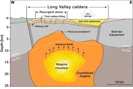
Calderas must be geophysically characterized to be evaluated for the likelihood of catastrophic volcanic eruptions in the future. Long Valley Caldera in California has experienced recent uplift and seismicity attributed to either the escape of aqueous fluids from the magma chamber or magma intrusion into the upper crust. The cause of this unrest is still up for question.
Reaching down as far as 10 kilometers below the Earth’s crust, Caltech scientists have produced the most in-depth photographs of the Long Valley Caldera underground yet. The Earth’s structure beneath the caldera is visible in these high-resolution photos, demonstrating that the current seismic activity results from fluids and gasses released as the region cools and settles.
The Eastern Sierra Nevada mountains of California have seen substantial periods of unrest since the 1980s. During these times, the ground has inflated and risen by approximately half an inch per year, and there have been swarms of earthquakes. The Long Valley Caldera, where the activity is taking place, sits on a sizable dormant supervolcano, which is alarming.
The Long Valley Caldera was created seven hundred and sixty thousand years ago during a massive eruption that ejected 650 cubic kilometers of ash into the atmosphere, enough to cover the whole Los Angeles region in a layer of sediment one kilometer thick.
For this study, scientists inferred the subsurface environment by measuring seismic waves from earthquakes. Primary (P-waves) and secondary (S-waves) seismic waves are produced during an earthquake. Both waves move through various materials at varying speeds; elastic materials like liquids delay them yet move faster through stiffer materials like rock.
Seismometers can be used to measure variations in wave timing and identify the properties of the materials the waves pass through, such as how elastic or rigid they are. Scientists may, therefore, create images of the subsurface environment.
Zhan’s method, known as distributed acoustic sensing (DAS), uses fiber optic lines (similar to those that supply the internet) to obtain seismic measurements even though several dozen seismometers are scattered around the Eastern Sierra region. It took 10,000 single-component seismometers over a 100-kilometer cable stretch to picture the Long Valley Caldera.
The scientists used the cable to measure almost 2,000 seismic events over 1.5 years, the majority of which were too tiny for people to feel. These measurements were analyzed by a machine learning system, which created the final image.
This work marks the first time DAS has been used to produce images with such depth and detail. Previous photos from local tomography studies covered a greater area in lesser resolution or were restricted to the shallow subsurface environment at depths of roughly 5 kilometers.
Ettore Biondi, DAS scientist at Caltech and the paper’s first author, said, “This is one of the first demonstrations of how DAS can change our understanding of crustal dynamics. We’re excited to apply similar technology to other regions where we are curious about the subsurface environment.”
Scientists plan to use a 200-kilometer length of cable to image even deeper into the Earth’s crust, to around 15 to 20 kilometers deep, where the caldera’s magma chamber—its “beating heart”—is cooling.
Journal Reference:
- Ettore Biondi, Weiqiang Zhu et al. An upper-crust lid over the Long Valley magma chamber. Science Advances. DOI: 10.1126/sciadv.adi9878