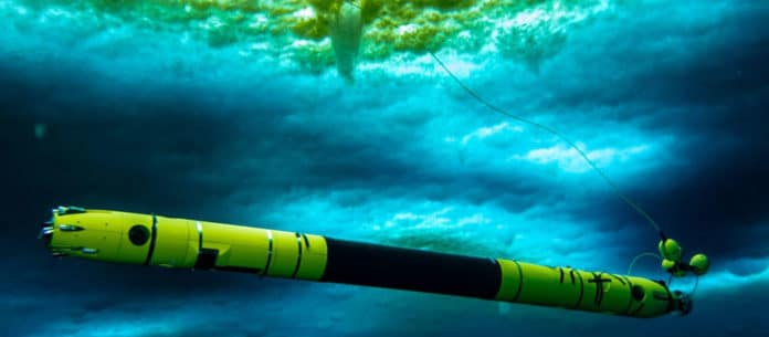
Scientists in Antarctica have recorded, for the first time have sent an underwater robot at the bottom of Antarctica’s Thwaites Glacier. They discovered unusually warm water beneath a glacier.
Thwaites Glacier, covering 192,000 square kilometers (74,000 square miles), an area the size of Florida or Great Britain, is particularly susceptible to climate and ocean changes. Over the past 30 years, the amount of ice flowing out of Thwaites and its neighboring glaciers has nearly doubled. Ice draining from Thwaites into the Amundsen Sea accounts for about four percent of global sea-level rise.
Stationed in Antarctica for the last two months, the MELT (Melting at Thwaites grounding zone and its control on sea level) team has captured new images and first-of-its-kind data from deep beneath an Antarctic glacier. The team included Georgia Tech scientists who used an underwater robot named Icefin to navigate beneath the glacier.
And the surprising discovery comes out.
Scientists were surprised to learn that waters at the ground line, the region where the glacier meets the sea, are more than 3.6 degrees Fahrenheit (2 degrees Celsius) above the normal freezing temperature.
Dr. Britney Schmidt, the lead scientist for Icefin and associate professor in Georgia Tech’s School of Earth and Atmospheric Sciences, said, “The underwater robot Icefin can access to grounding zones of glaciers. We’re proud of Icefin since it represents a new way of looking at glaciers and ice shelves. For really the first time, we can drive miles under the ice to measure and map processes we can’t otherwise reach. We’ve taken the first close-up look at a grounding zone. It’s our ‘walking on the moon’ moment.”
To sent the Icefin underneath at the bottom, scientists, at first, used hot water to drill through up to 2,300 feet – nearly a half-mile – of ice to get to the ocean and the seafloor below. On Jan. 9 and 10, Icefin swam more than a mile from the drill site to the Thwaites grounding zone to obtain essential data that scientists can use to understand the changing landscape and conditions.
Keith Nicholls, an oceanographer with the British Antarctic Survey and the United Kingdom lead on the MELT team, said in the Georgia Tech statement said, “We know that warmer ocean waters are eroding many of West Antarctica’s glaciers, but we’re particularly concerned about Thwaites. This new data will provide a new perspective of the processes taking place so that we can predict future change with more certainty.”
Along with Icefin, scientists sent out ocean instruments and took sediment cores.
Christina Hulbe of the Ross Ice Shelf Programme said, “We now have, effectively, a transect of conditions from the front of the Ross Ice Shelf to the grounding line. In addition to Icefin’s work, we’ve installed our third ice-anchored mooring, collected cores for sedimentary and microbiological analysis, we’ve imaged the ice optically and using radar, and made high-resolution observations of ocean conditions.”
