
Next month, NASA is planning to launch the most advanced laser instrument of its kind in space, that will estimate the changes in the heights of Earth’s polar ice.
The instrument, NASA’s Ice, Cloud and land Elevation Satellite-2 (ICESat-2) will gauge the average yearly elevation change of land ice covering Greenland and Antarctica to within the width of a pencil, catching 60,000 estimations consistently. It will also extend also, enhance NASA’s 15-year record of monitoring the change in polar ice heights, which began in 2003 with the principal ICESat mission and proceeded in 2009 with NASA’s Operation IceBridge, an airborne research crusade that monitored the quickening rate of progress.
Michael Freilich, director of the Earth Science Division in NASA’s Science Mission Directorate said, “The new observational technologies of ICESat-2 – a top recommendation of the scientific community in NASA’s first Earth science decadal survey – will advance our knowledge of how the ice sheets of Greenland and Antarctica contribute to sea level rise.”
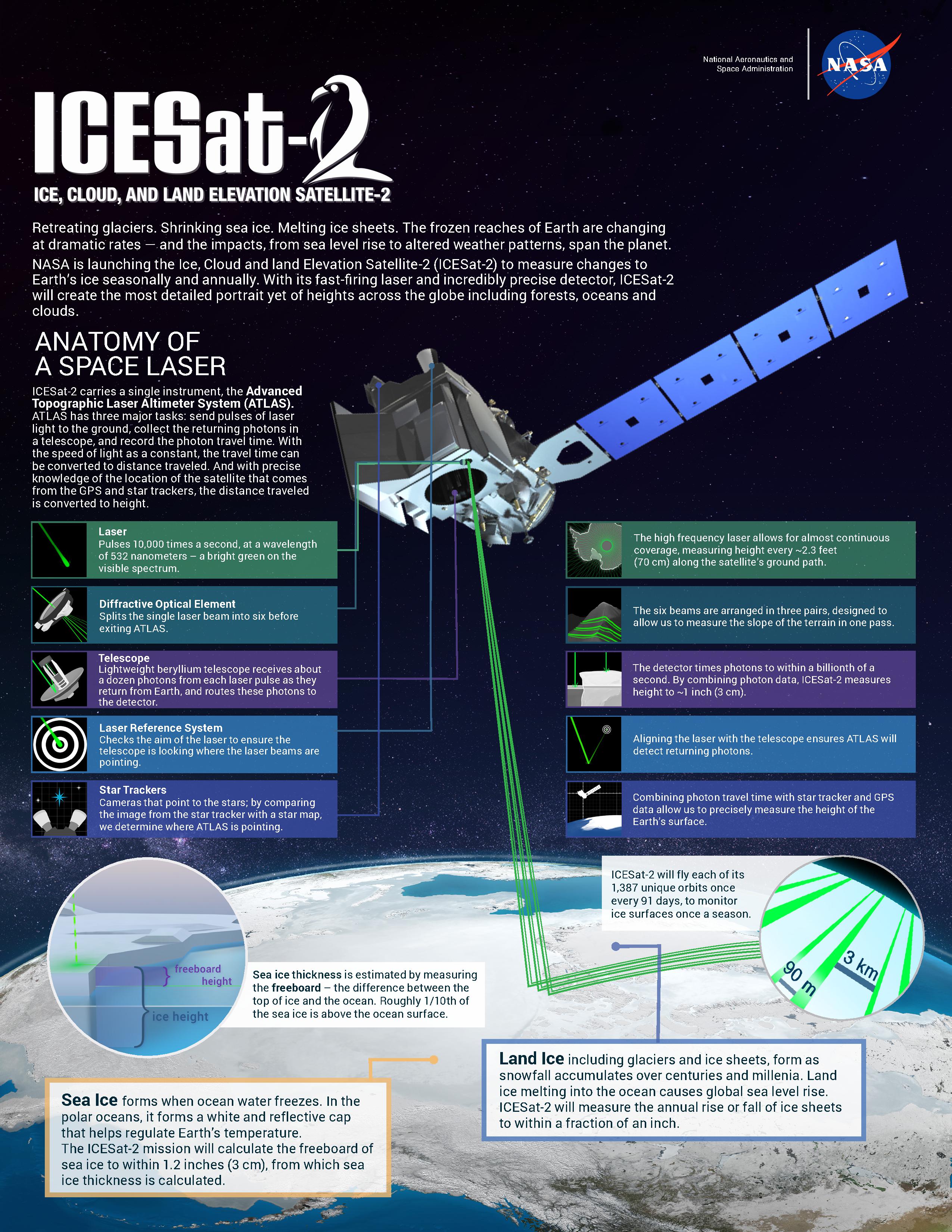
ICESAT-2’s Advanced Topographic Laser Altimeter System (ATLAS) measures height by timing how long it takes individual light photons to travel from the spacecraft to Earth and back.
Credits: NASA/Adriana Manrique Gutierrez
A Technological Leap
Doug McLennan, ICESat-2 project manager at NASA’s Goddard Space Flight Center said, “ATLAS required us to develop new technologies to get the measurements needed by scientists to advance the research. That meant we had to engineer a satellite instrument that not only will collect incredibly precise data, but also will collect more than 250 times as many height measurements as its predecessor.”
ATLAS will fire 10,000 times each second, sending hundreds of trillions of photons to the ground in six beams of green light. The roundtrip of individual laser photons from ICESat-2 to Earth’s surface and back is timed to the billionth of a second to precisely measure elevation.
With so many photons returning from multiple beams, ICESat-2 will get a much more detailed view of the ice surface than its predecessor, ICESat.
ICESat-2 data documenting the ongoing height change of ice sheets will help researchers narrow the range of uncertainty in forecasts of the future sea level rise and connect those changes to climate drivers. It will also make the most precise polar-wide measurements to date of sea ice freeboard, which is the height of sea ice above the adjacent sea surface. This measurement is used to determine the thickness and volume of sea ice.
ICESat-2 will quantify the height of ocean and land surfaces, including forests. ATLAS is intended to gauge both the highest points of trees and the ground beneath, which – combined with existing datasets on forest extent– will enable analysts to evaluate the measure of carbon stored in world’s forests. Specialists likewise will examine the height data gathered on ocean waves, reservoir levels, and urban areas.
Thorsten Markus, an ICESat-2 project scientist at Goddard said, “Because ICESat-2 will provide measurements of unprecedented precision with global coverage, it will yield not only new insight into the polar regions but also unanticipated findings across the globe. The capacity and opportunity for true exploration are immense.”
ICESat-2 is scheduled to launch Sept. 15 from Vandenberg Air Force Base in California.