
Bathymetry (seafloor depth), is a critical parameter providing the geospatial context for a multitude of marine scientific studies. Since 1997, the International Bathymetric Chart of the Arctic Ocean (IBCAO) has been the authoritative source of bathymetry for the Arctic Ocean.
Now, an international team of scientists has published the most detailed submarine map of the Arctic Ocean. The map is the 4.0 version of the International Bathymetric Chart of the Arctic Ocean (IBCAO).
Martin Jakobsson, professor at the Stockholm University (Sweden), who led the scientific team with experts from fifteen countries, together with Larry Mayer, from the University of New Hampshire (United States) said, “The 4.0 IBCAO map is this year’s contribution to the Nippon Foundation-GEBCO Seabed 2030, whose objective is to map all seas and oceans in the world by 2030.”
Professor Miquel Canals, head of the Consolidated Research Group on Marine Sciences of the UB, said, “The potential difficulty for the current science campaigns in the Arctic is the access to places which are permanently covered by marine ice, and the short duration of the navigation period. However, global warming made these inaccessible areas easier to reach now.”
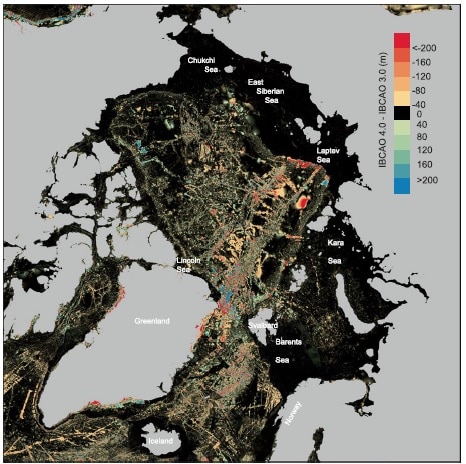
“The new cartography has a volume with a higher and better resolution data than the previous versions, and it includes marine regions which were unknown to date. This results from the efforts made by an international collaborative of many institutions and researchers who provided their scientific data to reach a common objective: discovering the depths of the Arctic Ocean.”
Scientists used the same technology used in the submarine study in other regions of the ocean to carry out the IBCAO 4.0 map. The compounds of the new map, fundamentally the latest ones, were acquired through the most advanced multibeam bathymetry systems that exist. These data originate from oceanographic vessels, ice breakers, and nuclear submarines, the only ones to map those areas under the iced tea, difficult to reach with other ships.
Canals said, “Regarding the data processing and fusion –with a new Mallat algorithm–, new techniques were added, and provided an excellent result.”
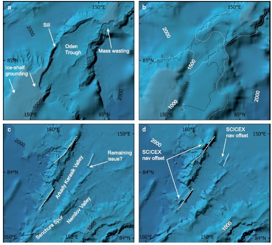
In general, better and larger cartography assists with broadening the knowledge on the geographical and glacial evolution of such a sensitive region like the Arctic. In this manner, the new bathymetric map identifies an incredible variety of the shapes of the alleviation with glacial origins, some at large scales— from hundreds to thousands of meters long—that show the direction of the movement of the ice on the ocean floor, which assists with reproducing the topographical procedures of the recent past in arctic latitudes.
Bathymetrical data are relevant in other fields of polar science, such as the study of the path of ocean currents, and therefore, the distribution of the heat, the sea-ice decline, the effect of inflowing warm waters on tidewater glaciers, and the stability of marine-based ice streams and outlet glaciers grounded on the seabed.
Canals said, “One of the most spectacular formations in the Arctic ocean floors is the Lomonosov Ridge, a geological element with more than 1,600 kilometers of length, which connects Northern Greenland and Siberia and crosses the ocean leaving deep basins in both sides. The most recent cartography studies carried out with ice breakers revealed the presence of thresholds that influence the exchange of water between both basins, and anchoring marks in ice platforms on the ridge.”
Within the frame of the international effort to study the Arctic marine floors, the Consolidated Research Group on Marine Geosciences of the UB is one of the teams that take part in the Nippon Foundation-GEBCO Seabed 2030, the most ambitious global project to complete an excellent task in marine geosciences: high-resolution submarine bathymetry in all oceans worldwide.
Journal Reference:
- Martin Jakobsson et al. The International Bathymetric Chart of the Arctic Ocean Version 4.0, Scientific Data (2020). DOI: 10.1038/s41597-020-0520-9