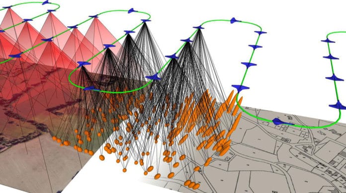
Drones are not just toys for big and little kittle– they likewise cater to numerous practical purposes. They can be utilized to screen dams and railways to forestall accidents or to make 3D digital copies of historical monuments if they are incidentally or intentionally destroyed. They can likewise catch pictures starting with one season then onto the next to quantify soil erosion.
Emmanuel Cledat, who has just completed his Ph.D. thesis at the Topo lab, said, “It’s essential to be as accurate as possible. When it looks like a cliff has moved slightly over the winter, you have to be able to tell whether it’s a real topographical change or just a georeferencing error.”
Cledat has spent the last four years developing software capable of accurately processing data acquired by sensors embedded on drones.
LIDAR is a commonly used technique, which measures distances by recording the time it takes for the laser beam to travel from the scanner to the object and back again.
Up to this point, LIDAR laser scanners could weigh as much as 10 kilos. The Topo lab, along with EPFL turn off Helimap System SA, were pioneers in developing aerial mapping systems, including helicopters, which can convey overwhelming gear like a LIDAR scanner and a navigation-grade IMU.
Be that as it may, as of late, both industry experts and scientists have been focused around making these estimating devices much smaller. Cledat was able to hybridize the information procured by miniaturized sensors installed on a drone (a GNSS, LIDAR, IMU, and camera) to such an extent that the subsequent guide is nearly as exact as those obtained with a helicopter. A drone-based mapping technique is a greener alternative option, and one progressively fit hard-to-reach terrain.
This new software uses to cross-check the measurements to correct them all simultaneously. This results in an accurate image of the area and of the drone‘s position and orientation. Cledat’s software will be further developed within the lab as part of another thesis project.
In this project, Cledat carefully calibrated each sensor to make them as effective and reliable as possible. He did this by using the lab’s calibration fields near Vufflens-la-Ville in Vaud Canton.
For this work, he had received the ISPRS award.
Journal Reference
- Emmanuel Cledat, “On the adjustment, calibration and orientation of drone photogrammetry and laser-scanning,.
- Emmanuel Cledat, Camera calibration models and methods in corridor mapping with UAVs,” ISPRS Annals of the Photogrammetry, Remote Sensing and Spatial Information Sciences, XLIII, 2020.
- E. Cledat, J. Skaloud, “Fusion of Photo with Airborne Laser Scanning,” ISPRS Annals of the Photogrammetry, Remote Sensing and Spatial Information Sciences, XLIII, 2020.
- E. Cledat, D. A. Cucci, “Mapping GNSS restricted environments with a drone tandem and indirect position control,” ISPRS Annals of Photogrammetry, Remote Sensing and Spatial Information Sciences, vol. IV-2/W3, pp. 1–7, 2017.
