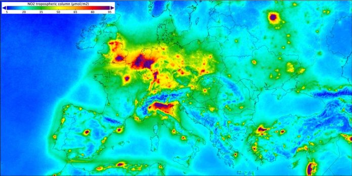
Air pollution is a major concern of the new civilized world, which has a serious toxicological impact on human health and the environment. It has a number of different emission sources, but motor vehicles and industrial processes contribute to the major part of air pollution.
An estimated 8 million premature deaths per year are linked to air pollution, suggests the World Health Organization (WHO). And this is twice than previously estimated.
Among all major pollutants, nitrogen dioxide has the strongest health effects. In Europe itself, the road transport sector is the largest contributor to nitrogen dioxide emissions.
Not only is nitrogen dioxide damaging the ecosystem, but it also causes significant health issues contributing to respiratory problems ranging from causing cardio-pulmonary ailments to exacerbating asthma and even impacting cognitive abilities.

As air quality becoming a serious concern, scientists have now decided to map a multitude of air pollutants around the globe using the Copernicus Sentinel-5P satellite. With its state-of-the-art instrument, Tropomi, it is able to detect atmospheric gases to image air pollutants more accurately and at a higher spatial resolution than ever before from space.
Folkert Boersma, Associate Professor at Wageningen University and Research Scientist from the Royal Netherlands Meteorological Institute (KNMI), comments, “The spatial resolution of the satellite are so good, that we can pinpoint emissions in fine detail and also detect gradients of emissions in large cities.”
As part of the Living Planet Symposium School Lab taking place in Milan this week, ESA has given schools around the Lombardy and Milan area, the exciting opportunity to assemble and operate their own air monitoring stations. The Living Planet Symposium School Lab aims to make school students to discover the exciting science and technology behind Earth observation.
Based on a Rasperry Pi computer, each station is equipped with a set of sensors to measure different characteristics of ambient air. The stations measure nitrogen dioxide, carbon dioxide, carbon monoxide, and particulate matter, as well as temperature and humidity. They also have a GPS receiver for positioning. Once the platform has Wi-Fi access, it automatically sends its measurements to an online map where they can be retrieved in real time.
Throughout the week, the results will be published on an interactive map, showcasing how both children and citizens can contribute in monitoring different air quality parameters, as well as gaining insight regarding air pollution and how satellite missions can help monitor these issues.
