
Salars are brine-bearing evaporite deposits that form in dry areas where surface water bodies are at risk of aridity and resource extraction. Surface water inundation is temporally sensitive to climatic changes because high evaporation rates outpace input rates, which could be decreased as temperatures rise.
The University of Massachusetts Amherst and the University of Alaska Anchorage were the first to characterize two distinct forms of surface water in the hyperarid salar, or salt flats, that contain most of the world’s lithium reserves.
This new classification significantly advances the understanding of how water moves across such basins. It will be crucial in minimizing the environmental impact on such sensitive, critical habitats.
Sarah McKnight, a lead author of the research that appeared recently in Water Resources Research, said, “You can’t protect the salars if you don’t first understand how they work.”
A salar is a huge shallow depression into which water regularly flows, both from the surface and the much slower flow of underground waters. There is no exit for the water in this depression. Because the bowl is in an exceedingly arid region, the evaporation rate is such that huge salt flats have formed over millennia.
The water in this depression comes in several varieties; the water is fresher the closer it is to the bowl’s edge, while the water in the depression’s bottom, where the salt flats are located, is extremely salty. The salt flats do, however, occasionally contain pockets of brackish water.
Lithium and other important metals can be found in abundance in salt flats, and brackish water pools provide vital habitats for creatures like flamingos and vicunas.
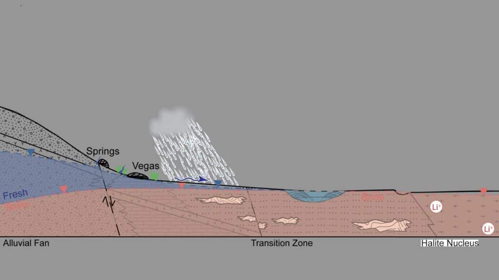
One of the difficulties in understanding these systems is that many salars are inaccessible. McKnight is studying the Salar de Atacama in Chile, located between the Andes and the Atacama Desert.
Hydrogeology is complex, and it is difficult to determine the process through which snow and groundwater eventually transform into salt flats.
However, by combining surface and groundwater observations with Sentinel-2 satellite data and powerful computer modeling, McKnight and her colleagues could see something that had previously been invisible to other researchers.
Sarah McKnight, geosciences doctorate student at UMass Amherst, said, “After a large storm, terminal pools flood fast and then quickly retreat to pre-flood levels. However, transitional collections take much longer—from a few months to almost a year—to recede back to normal levels.”
McKnight and her colleagues discovered that not all water in the salar is the same and that this is crucial habitat for a variety of creatures.
It turns out that not all Salar’s water is the same. McKnight and her colleagues refer to “terminal pools” as brackish ponds of water lying in the “transition zone,” or the area of the Salar where the water is becoming progressively briny but have not reached maximum concentration.
Then there are the “transitional pools,” which are placed right on the briny water-salt flats line. Water enters each of these pools from many sources, some of which are quite far away from the pools they feed and exits through various channels.
She said, “It’s important to define these two different types of surface waters because they behave very differently. After a major storm, the terminal pools flood quickly and recede to their pre-flood levels. But the transitional pools take a very long time—from a few months to almost a year—to recede to their normal level after a major storm.”
All of this has an impact on how these ecosystems are handled. She also said, “We need to treat terminal and transitional pools differently, which means paying more attention to where the water in the pools comes from and how long it takes to get there.”
The Albemarle Corporation funded the study.
Journal Reference:
- McKnight, S. V., Boutt. Distinct Hydrologic Pathways Regulate Perennial Surface Water Dynamics in a Hyperarid Basin. Water Resources Research. DOI: 10.1029/2022WR034046