
A major question in Mars’s history is whether the planet had an ocean in its low-elevation northern hemisphere. In a new study, scientists from Pennsylvania State University show evidence that an ancient ocean in Mars’ northern hemispheric basin during the Noachian/Hesperian is contentious.
The maps present the most compelling evidence that the planet’s current harsh, frozen surface is not what it formerly looked like and that sea levels rose in accordance with an extended period of warm, humid weather.
Benjamin Cardenas, assistant professor of geosciences at Penn State and lead author on the study, said, “What immediately comes to mind as one the most significant points here is that the existence of an ocean of this size means a higher potential for life.”
“It also tells us about the ancient climate and its evolution. Based on these findings, we know there must have been a period when it was warm enough, and the atmosphere was thick enough to support this much liquid water at one time.”
“Using topography data, the research team was able to show definitive evidence of a roughly 3.5-billion-year-old shoreline with substantial sedimentary accumulation, at least 900 meters thick, that covered hundreds of thousands of square kilometers.”
“The big, novel thing that we did in this paper was think about Mars in terms of its stratigraphy and its sedimentary record. On Earth, we chart the history of waterways by looking at sediment deposited over time. We call that stratigraphy, the idea that water transports sediment, and you can measure the changes on Earth by understanding how sediment piles up. That’s what we’ve done here—but it’s Mars.”
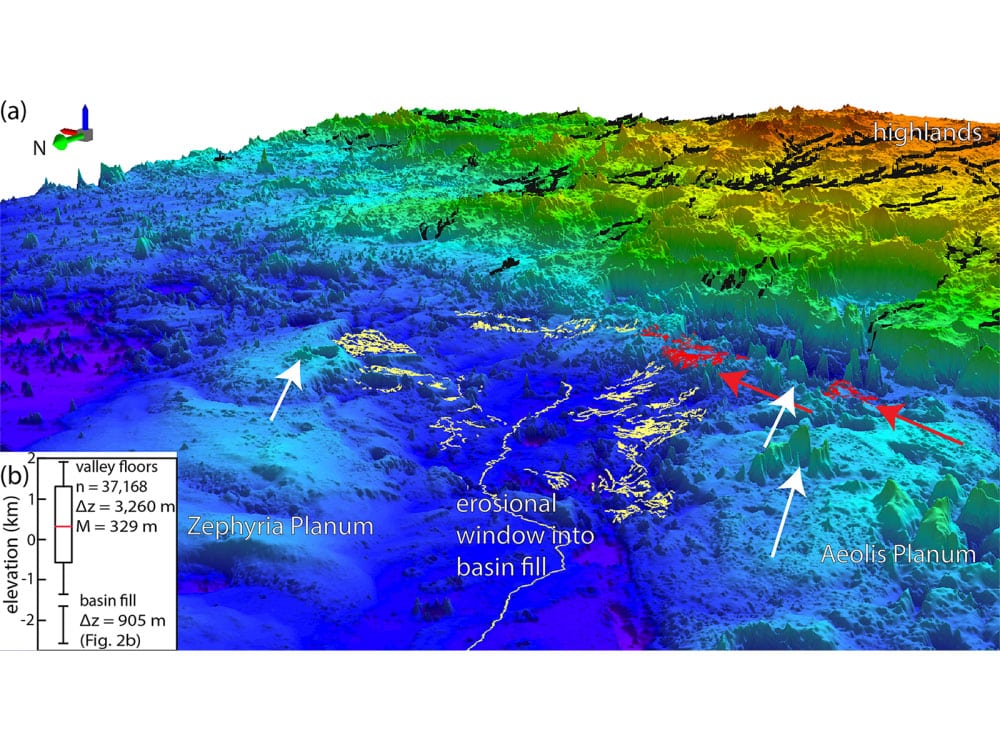
The group mapped data from NASA and the Mars Orbiter Laser Altimeter using software created by the United States Geological Survey. They found approximately 6,500 kilometres of fluvial ridges. They organized them into 20 systems to demonstrate that the ridges are probably the remains of an old Martian coastline that has been eroded into river deltas or undersea channel belts.
Cardenas said, “Elements of rock formations, such as ridge-system thicknesses, elevations, locations, and possible sedimentary flow directions, helped the team understand the evolution of the region’s paleogeography. The area once ocean is now known as Aeolis Dorsa and contains the densest collection of fluvial ridges on the planet.”
“The rocks in Aeolis Dorsa capture some fascinating information about what the ocean was like. It was dynamic. The sea level rose significantly. Rocks were being deposited along its basins at a fast rate. There was a lot of change happening here.”
“On Earth, the ancient sedimentary basins contain the stratigraphic records of evolving climate and life. If scientists want to find a record of life on Mars, an ocean as big as the one that once covered Aeolis Dorsa would be the most logical place to start.”
“A major goal for the Mars Curiosity rover missions is to look for signs of life. It’s always been looking for water, for traces of habitable life. This is the biggest one yet. It’s a giant body of water, fed by sediments from the highlands, presumably carrying nutrients. If there were tides on ancient Mars, they would have been here, gently bringing in and out water. This is exactly the type of place where ancient Martian life could have evolved.”
On Mars, scientists have traced what they believe to be additional ancient canals. The Curiosity rover presumably encountered sedimentary strata from old river bars at a number of outcrops.
In another study, scientists applied an acoustic imaging technique to view stratigraphy beneath the Gulf of Mexico’s seafloor to a model of Mars-like basin erosion. They determined that the landforms called fluvial ridges, found widely across Mars, likely eroded ancient river deposits from large basins similar to Aeolis Dorsa.
Cardenas said, “The stratigraphy that we’re interpreting here is quite similar to stratigraphy on Earth. Yes, it sounds like a big claim to say we’ve discovered records of large waterways on Mars, but in reality, this is relatively mundane stratigraphy. It’s textbook geology once you recognize it for what it is. The interesting part, of course, is it’s on Mars.”
Journal References:
- T. Cardenas et al., Paleogeographic Reconstructions of an Ocean Margin on Mars Based on Deltaic Sedimentology at Aeolis Dorsa, Journal of Geophysical Research: Planets (2022). DOI: 10.1029/2022JE007390
- Benjamin T. Cardenas et al., Martian landscapes of fluvial ridges carved from ancient sedimentary basin fill, Nature Geoscience (2022). DOI: 10.1038/s41561-022-01058-2