Thematic map creation is a meticulous process that requires several steps to be accomplished regardless of the type of map to be produced, from data collection, through data exploitation and map publication in print, image, and GIS format. Examples are geolithological and geomorphological maps, in which most of the highest time-consuming tasks are those related to the discretization of single objects—also introducing interpretative biases because of the different experiences of the mappers in identifying a set of unique characteristics that describe those objects.
Deep Learning techniques, which use artificial neural networks to analyze data sets, can significantly improve the production process, as broadly shown in scientific literature and applications. However, until now, open-source, ready-to-use, and highly customizable toolsets for planetary mapping have yet to be released.
A new study by the Jacobs University Bremen CGMBH reported DeepLandforms, the first pre-release of landform mapping tools using Deep Learning that includes all the components for data set preparation, model training, monitoring, and inference.
Giacomo Nodjoumi from the Constructor University Bremen gGmbH said, “We were interested in designing a simple, out-of-the-box tool that can be customized and used by many.”
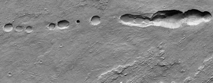
The scientists demonstrated the results that can be achieved with the help of the software for planetary mapping with a specific landform on Mars, which resembles lava tubes on Earth. Geological maps are an essential tool in planetary exploration because they also serve as a basis for possible explorations by robots or humans.
Journal Reference:
- Giacomo Nodjoumi, Riccardo Pozzobon et al. DeepLandforms: A Deep Learning Computer Vision Toolset Applied to a Prime Use Case for Mapping Planetary Skylights. Earth and Space Science. DOI: 10.1029/2022EA002278
