
Scientists at the Brown University for the first time have created the first quantitative map of water and its chemical building blocks trapped in the uppermost portion of the Moon’s soil. According to scientists, the study may prove useful for lunar explorers.
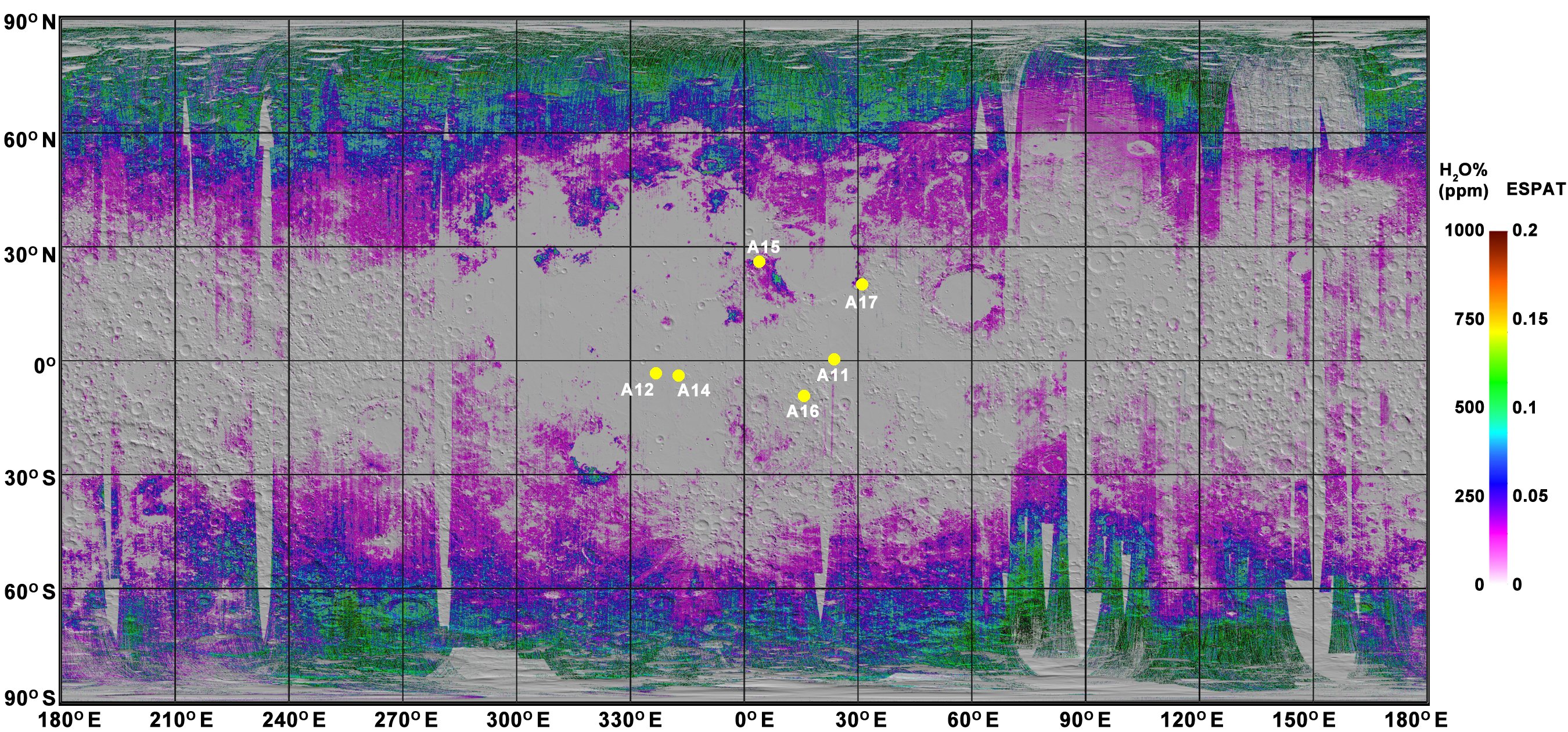
Here, scientists used data from NASA’s Moon Mineralogy Mapper, which flew aboard India’s Chandrayaan-1 spacecraft. They then measured how much water is present on a global scale.
Study’s lead author, Shuai Li said, “The signature of water is present nearly everywhere on the lunar surface. It is not limited to the polar regions as previously reported. The amount of water increases toward the poles and does not show significant difference among distinct compositional terrains.”
Robert Horton / Brown University
Ralph Milliken, an associate professor at Brown said, “This is a roadmap to where water exists on the surface of the Moon. Now that we have these quantitative maps showing where the water is and in what amounts, we can start thinking about whether it could be worthwhile to extract, either as drinking water for astronauts or to produce fuel.”
The water disruption on the moon is largely uniform than splotchy, with concentrations that gradually decreasing toward the equator. This pattern remains constant with implantation via the solar wind.
Scientists also outlined bulk of the water that could be traced to the solar wind. For example, the researchers found higher-than-average concentrations of water in lunar volcanic deposits near the Moon’s equator, where background water in the soil is scarce.
Scientists reported, “Instead of coming from solar wind, the water in those localized deposits likely comes from deep within the Moon’s mantle and erupted to the surface in lunar magma.”
During lunar days at latitudes lower than 60 degrees, this concentration of water changes. It goes wetter in the early morning and evening and much drier during noon time.
Milliken said, “We don’t know exactly the mechanism behind this fluctuation. But it tells us that the process of water formation in the lunar soil is active and happening today. This raises the possibility that water may re-accumulate after extraction, but we need to better understand the physics of why and how this happens to understand the timescale over which water may be renewed.”
As important these maps are, they still leave some unsolved mysteries behind about lunar water. The Moon Mineralogy Mapper measured light reflected off of the lunar surface. Means, it can’t look for water in places that are covered from the sun’s rays. According to many scientists, such covered places could hold large deposits or water ice.
Milliken said, “Those ice deposits may indeed be there. But because they are in shadowed areas it’s not something we can easily confirm using these data.”
“Here, We’re only sensing the upper millimeter or so of soil, and we can’t say for sure what the water content is like underneath that. The distribution of water with depth could make a big difference in terms of how much water is actually there.”
“It remains to be seen whether extraction could be feasible. But these results show us what the range of water availability across the surface is so we can start thinking about where we might want to go to get it and whether it makes economic sense to do so.”