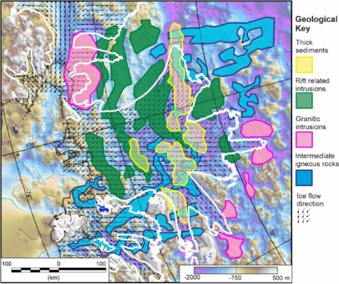
For the first time, the ground behind Antarctica’s most vulnerable glacier has been mapped, allowing scientists to understand better how climate change affects it. The geology below West Antarctica’s Thwaites Glacier reveals less sedimentary rock than expected, which might affect how the ice slides and melts in the future decades.
Dr. Tom Jordan, a geophysicist with the British Antarctic Survey (BAS), who led the study, said, “Sediments allow faster flow, like sliding on mud; now we have a map of where the slippery sediments are, we can better predict how the glacier will behave in future as it retreats.”
A new map of the region’s geology created by BAS researchers and published in the Science Advances journal includes sedimentary rocks’ distribution beneath the Thwaites glacier. The discoveries are significant because the glacier, the size of the United Kingdom or the state of Florida in the United States, is one of Antarctica’s fastest-moving ice-ocean systems.
The grounding zone of the Thwaites glacier, where it meets the seafloor, has decreased by 14 kilometers since the late 1990s. Much of the ice sheet lies below sea level, making it vulnerable to rapid, irreversible ice loss, which could raise global sea levels by more than a meter in centuries.
The new study is based on airborne surveys conducted by planes outfitted with radar and sensors capable of mapping minute fluctuations in gravity and magnetism hundreds to thousands of meters beneath the land and seabed where the glacier lies.
The researchers then utilize these various data sources to create a 3D representation of features, such as the type and extent of certain rocks.
Jordan said, “The integrated nature of the airborne surveys was one of the keys to this research. Each sensor on the aircraft provided an important but incomplete part of the picture, but by bringing them all together, we could provide the detailed map of the underlying geology.”
The research pulls back the geological clock to investigate what happened when New Zealand had ripped away from Antarctica approximately 100 million years ago, long before the Thwaites glacier developed.
Thwaites Glacier is well below sea level, and experts expected massive sediments to be deposited there for millions of years.
Thwaites Glacier’s base is considerably below sea level. Therefore, scientists expected that heavy sediments would have accumulated over millions of years. Other Antarctic glaciers have undergone similar research, which revealed that their primary substructures were substantial sediments.
According to data from aircraft, just around 5% of the ground below the glacier is made up of sedimentary rock.
These are spread out over a number of basins that are between 80 and 200 km long and 30 km wide. Other geological bodies, such as granite peaks and hard rocks, comprise the remaining portion. According to scientists, these sedimentary basins were once much larger but were reduced in size by glacier movement to the bedrock level.
The rest of it is made up of other types of geological bodies, such as granite peaks and other hard rocks. The map shows rift-related intrusions flowing perpendicular to the glacier’s front, with some thick sediment regions far deeper inland.
It is still being determined how this new subglacial geology knowledge will alter estimates of ice flow and loss from Thwaites and other glaciers. The study discovered that the geological topography directly influences basal shear stress, which influences how quickly ice flows into the ocean.
The researcher said, “We hope that by showing the detailed geology and how it correlates with the basal friction, future models of the glacial retreat will have lower uncertainty, as the controls of the basal processes will be better understood.”
He added, “No single scientific study could ever match climate change‘s sheer scale and challenge. But the incremental building of all the individual scientific studies like this allows us to understand and tackle that challenge.”
Dr. Sarah Thompson, a glaciologist and co-author of the report, stated that the comprehensive method utilized in this study has the potential to be successfully used elsewhere in Antarctica, allowing us to examine other potentially vulnerable places where existing understanding is limited.
Researchers will now conduct more extensive examinations of these processes, and modelers can utilize the new data to generate more solid estimates of future ice loss.
Journal Reference:
- Jordan, T. A., Thompson, S., Kulessa,et al. Geological sketch map and implications for ice flow of Thwaites Glacier, West Antarctica, from integrated aero geophysical observations. Science Advances. DOI: 10.1126/sciadv.adf2639
